PORTAGE, Maine — While the threat of flooding in Aroostook County has diminished in most areas, some Portage homes and camps were being affected Thursday by rising water.
Town officials are reporting flooding along the shores of Portage Lake, according to Darren Woods, director of the Aroostook County Emergency Management Agency.
“I am not sure how many places have been impacted at this point,” he said. “I just know that some homes up there along the lake shore are surrounded by water and some of the camps have water up to them.”
In southern Aroostook, the Bancroft Road in Bancroft also was closed due to flooding, according to Woods.
“As far as I know, that is the only road closure left at this point,” he said.
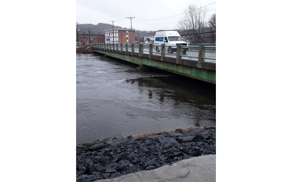
Woods said that officials were cautiously optimistic about avoiding major flooding in the region. The Maine Department of Transportation reopened the Fish River Bridge in Fort Kent on Wednesday morning after water levels receded in the Fish River. DOT closed the bridge off to traffic at 5:30 a.m. Tuesday in response to rising river water that reached the bottom of the structure that connects East and West Main streets in the downtown area.
The Fish River remained at 10.19 feet at 10:45 a.m. Thursday, which was still near flood stage of 11 feet.
“We are still watching that, of course,” Woods said. “We are expecting more rain in the next few days, which is going to increase the water levels of area streams, rivers and lakes.
According to the National Weather Service in Caribou, additional rainfall amounts of 1 inch are possible in Aroostook County Friday afternoon through Saturday. In addition to the rainfall, snowmelt will continue, as 2 to 3 inches of water remains in the snowpack in the higher elevations.
At the same time, strong winds also are expected this weekend, which could further shift existing ice on area lakes, Woods said. This could further impact camps along Portage Lake.